Greenprint for a sustainable City.
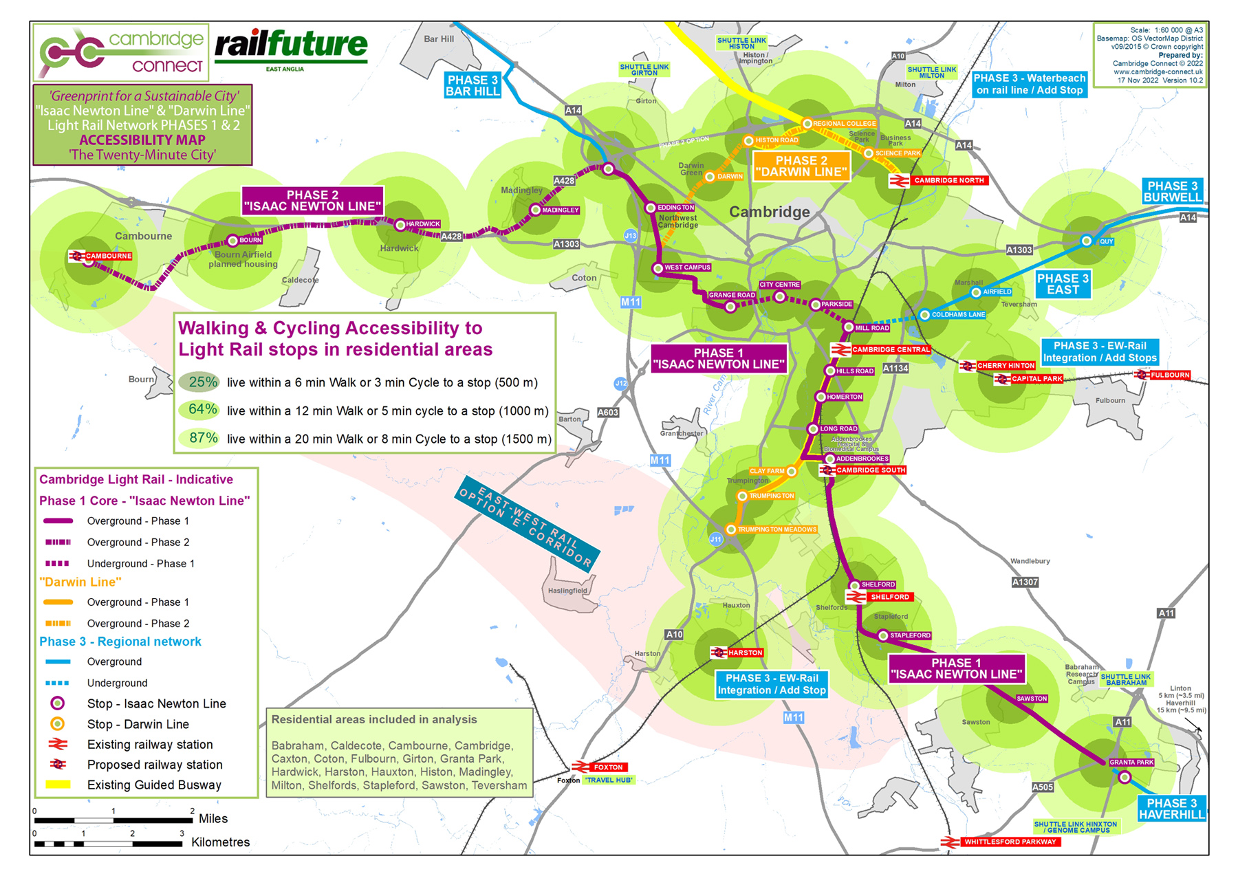
The accessibility of Cambridge Light Rail stops to residential / commercial areas in Cambridge is illustrated by the adjacent map. The percentage area of the city that is accessible on foot and by cycle to Light Rail stops is summarised in the table below. The map shows an accessible and attractive public transport alternative that would be transformative for inner city traffic, as more people decide to walk or cycle to their nearest stop and, instead of driving their car, take Cambridge Light Rail to their destination of choice. We believe this is a ‘Greenprint for a Sustainable City’.
Download Cambridge Connect’s ‘‘The Twenty-Minute City’ as a pdf.
| Distance to stop (m) | Walk time to stop (mins) | Cycle time to stop (mins) | City area accessible (%) |
| 500 | 6 | 3 | 25 |
| 1000 | 12 | 5 | 64 |
| 1500 | 20 | 8 | 87 |
Data show that a high proportion of people travel short distances by cycle in Cambridge (~30 % of commuting), and this is likely to influence significantly the distance at which stops on the network are considered “in scope”. This makes Cambridge substantially different to other cities in the UK. The Cambridge Light Rail network would be accessible to 87% of people living within an 8 minute cycle ride to a stop, or a 20 minute walk. This is one reason why we call the Cambridge Light Rail network the ‘Twenty Minute City’.
To calculate the number of people “within scope” in the Cambridge context, we included in the above calculations the built-up areas of Cambridge City, Grantchester, Cambourne, Caldecote, Coton, Girton, Hardwick, Histon, Milton Fulbourn, Trumpington, Harston, Hauxton, Shelfords, Stapleford and Sawston. Non-urbanised land on the periphery of the Cambridge City yet within the City boundary was not included in the accessibility calculations to provide a more realistic assessment of how close the stops are to residential, commercial and employment areas. The northern villages close to the A14 were included in accessibility calculations because of their proximity, their important commuter role, and because of the traffic they generate for the A14 and along principal arterial routes into Cambridge, particularly on Histon and Milton Roads.